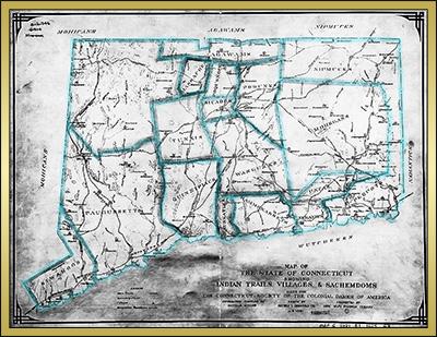
Norwich Historical
Maps and Drawings

Choose aN Historical Map or Drawing

1625
Indian Sachemdoms
1659_Nine_Mile_Square_500px
1659
The Nine-Miles Square
1660_Founders_Lots_edited
1660
First House Lots
1660_Norwichtown_gates
1670
Gates & Fences
1705_Map_of_Southeastern_Norwich
1705
Southeastern Norwich
1795_Map1_500px
1795
Norwichtown
c1830_Perkins_map_small
circa 1830
Town & City of Norwich
1833_Map_of_Norwich_400px
1833
Town & City of Norwich
1836_Norwichtown_color
1836
Norwichtown
1836_View_of_Norwich_bw
1836
View of Norwich City
1840_1898_Norwich_and_Worcester_RR_400px
1843
Norwich & Worcester RR
1849_Norwich_from_West_Side_500px
1849
View of Norwich from West
1850_Plan_of_Norwich_McIntyre
1850
Map of Norwich
1853_Crocker_art
1853
View of Norwich from South
map_Bean_Hill_Historic_District_400px
1854
Bean Hill Historic District
NRHP_Greenville_1854_and_Modern_Map_400px
1854
Greeneville Historic District
1854_Map_of_Norwich_Walling_400px
Two 1854
Maps of Norwich
1861_Greeneville_Manufacturers_Lithograph_500px
1861
Greeneville Manufacturers
1861_Norwich_from_Laurel_Hill_500px
1861
View of Norwich
Looking from Laurel Hill
1861_Norwichtown_Lithograph_500px
1861
Norwichtown Lithograph
1861_Yantic_Falls_500px
1861
Yantic Falls Manufacturers
1865_Map_of_Norwich
1865
Map of Norwich
1868_Map_of_Norwic_and_Yantic_400px
1868
Norwich Town & Yantic
1868_City_of_Norwich_800px
1868
City of Norwich
1868_West_Farms_Map_800px
1868
Norwich West Farms
1876_Norwich_Transportation_System_500px
1876
Norwich Transportation
1877_Stedmans_Norwich_Map_400px
1877
Map of Norwich
1885_Map_of_Thames_River_400px
1885
Map of Thames River
1885_Sanborn_fire_insurance_map_400px
1885
Sanborn Fire Insurance Map
1892_Sanborn_fire_insurance_map_400px
1892
Sanborn Fire Insurance Map
1893_Norwich_Town_Norwich_City_400px
1893
Norwich Town & City
1897_Sanborn_fire_insurance_map_400px
1897
Sanborn Fire Insurance Map
1903_Sanborn_fire_insurance_map_400px
1903
Sanborn Fire Insurance Map
1906_Norwich_Harbor
1906
Norwich Harbor
1903_Sanborn_fire_insurance_map_400px
1909
Sanborn Fire Insurance Map
1912_Map_Commonwealth_Works_500px
1912
Commonwealth Works Site
1903_Sanborn_fire_insurance_map_400px
1914
Sanborn Fire Insurance Map
1918_Price_and_Lee_Map_600px
1918
Price & Lee Map of Norwich
1934 Aerial Map of Norwich-Small
1934
Aerial Photo of Norwich
Todays_railroads_500px
Present
Norwich Railroads

Modern Interactive Norwich Maps

A collection of modern, up-to-date, maps sponsored by the  City of Norwich are available at the website below

An older, interactive topographic map of Norwich can be accessed at the Topozone website below

For those of you who are curious where Norwich, United Kingdom is located, a map is provided below.

Click on the map for more detail

Norwich_UK
Norwich, United Kingdom