Administrative Events

Choose An Administrative Event

1660-2020 Norwich Population

Greatest population increases occurred from 1850-1860 (129%) and 1950-1960 (64%)

1659 DEED TO NORWICH

In May of 1659, the residents of Saybrook petitioned the General Court of Connecticut for permission to create a settlement in the area that is now known as Norwich. On May 20, 1659 the Court approved and consented to “what is desired by ye petitioners, respecting the Mohegin, provided yt within ye space of three yeares they doe effect a plantation in ye place propounded”.

The next month on June 6, 1659 the deed for the land was was signed by Uncas and his sons for the price of £70 pounds, (Approximately $11,000 in today’s dollars). After an initial survey of the land was completed in the fall of 1659 a few of the settlers removed from Saybrook to the new plantation. However, no goods were moved until the spring of 1660.

According to Info Source 1 the town was first settled under the name Mohegan and received its present name in 1662.

The image above illustrates the signatures (marks) of the Mohegan signers on the deed to Norwich. The deed was signed by Uncas and two his two of his sons, Owaneco and Attawanhood.

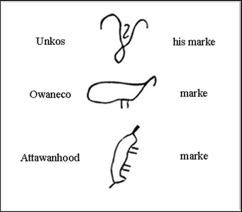
Uncas was married to the daughter of the principal Pequot sachem Tatobem. They had four sons and at least one daughter. Owaneco (Uncas’ father was also named Owaneco), Attawanhood,  (a.k.a. Joshua) who became the sachem of the western Niantic Indians, John I, and Benjamin.  Uncas’ brother was Waweekus, for whom Wawecus Hill in Norwich is named.

A transcript of the deed to Norwich, signed by Uncas and others is provided below.

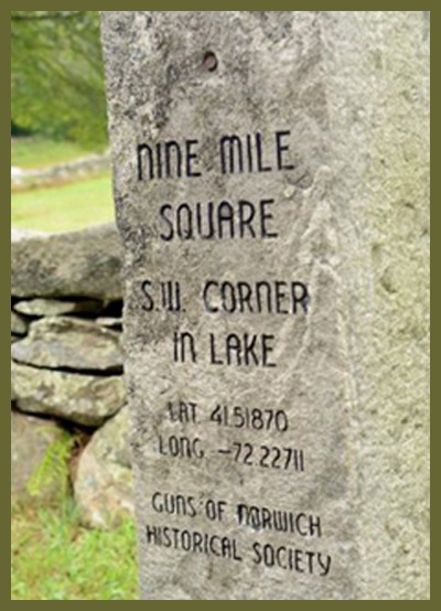
“Know all men that Onkos, Owaneco, Attawanhood, Indians of Mohegan, have Bargained, sold, and passed over, and doe by these presents sell and pass over unto the Towne and Inhabitants of Norwich nine miles square of land lying and being at Moheagan and the parts thereunto adjoyneing, with all ponds, rivers, woods, quarries, mines, with all royalties, privileges, and appurtenances thereunto belonging, to themthe said inhabitants of Norwich, theire heirs and successors forever-the said lands are to be bounded as followeth, (viz.) to the southward on the west side of the Great River, ye line is to begin at the brooke falling into the head of Trading Cove, and soe to run west norwest seven miles-fron thence the line to run nor north east nine miles, and on the East side the afores’d river to the southward the line is to joyne with New London bounds as soe from thence the line is to run nor noreast nine miles and from thence to run nor norwest nine miles to meet with the western line.-In consideration whereof the sd Onkos, Owaneco and Attawanhood doe acknowledge to have received of the parties aforesd the full and juste sum of seventy pounds and doe promise and egage ourselves, heirs and successors, to warrant the sd bargin and sale to the aforsd parties, their heirs and successors, and them to defend from all claims and molestations from any whatsoever.-In witness whereof we have hereunto set to our hands this 6th of June, Anno 1659.”

Acknowledgements

“Vital Records of Norwich, 1659-1848, Part 1, (1913)”,  page 7

“History of Norwich, Connecticut: From Its Possession From the Indians, to the Year 1866”,  page 57, by Frances Manwaring Caulkins

“History of Norwich, Connecticut: From Its Possession From the Indians, to the Year 1866”, page 58, by Frances Manwaring Caulkins

1659 The Nine-MileS Square

The map below shows the location of the original nine-miles square, as it was defined on the 1659 deed to Norwich.  The present-day boundary is also shown as a black outline.

The area of the original nine-miles square was approximately 122 square-miles and today’s Norwich encompasses approximately 30 square-miles. So, the original boundary of Norwich included far more land than today’s boundary.


More information about each of the four cornerstone markers is provided in placemarks below.

1659 Northwest Corner

The monument marks the northwest corner of land purchased from Mohegan Chief Uncas in 1659 for £70 pounds of sterling, (approximately $11,000 in today’s dollars.) The borders of Norwich, when it was founded nearly 350 years ago, measured roughly nine miles on each edge. The spot where the stone was placed, near the Shetucket River, is the approximate location. Tollmann said :”The best guess is the original location was flooded when the Scotland dam was constructed, which widened the river. So it’s now somewhere under water“.

Acknowledgements

 “New Marker Notes Old Boundary for Original Norwich Land Grant”, 10/20/2007, by Greg Smith

 “New Marker Notes Old Boundary for Original Norwich Land Grant”, 10/20/2007, by Greg Smith

1659 Northeast Cornerstone

When the town of Norwich was founded in 1659, the boundary markers for the land were commonly referred to as the “Nine Miles Square.” According to Daniel Phillips’, “History of Griswold”, in 1916 the Anne Brewster Fanning Chapter of the Daughters of the American Revolution took it upon themselves to identify and restore the ancient Norwich N.E. corner marker located in Griswold/Plainfield. The marker reads: 

Ye Antient Norwich

N.E. Corner Boundry

D.A.R. 

According to research by Griswold resident Steven Douglas, the marker identifies the meeting of the Norwich, Preston (now Griswold) and Plainfield town lines. The date 1659 refers to the founding of Norwich, 1917 likely refers to the founding of the monument and D.A.R. are the recognizable initials of the Daughters of the American Revolution.

Acknowledgements

“Hidden in Plainfield, Tri-town Line A Part of History”, 08/03/2017, by Stephanie Menders

“Hidden in Plainfield, Tri-town Line A Part of History”, 08/03/2017, Stephanie Menders

1659 Southeast Cornerstone

On June 23, 2012, the Guns of Norwich Historical Society dedicated a monument at the site of the Southeast Cornerstone. It  located near Rose Hill in Ledyard.

Acknowledgements

“Final Nine Mile Square Marker a Reminder of History”,  08/05/2017, by Stephanie Menders

Norwich Town Hall

1659 Southwest Cornerstone

The southwest marker isn’t in the exact location of the southwest corner, instead sitting on the corner of Lake Road and Witter Road, directly in front of 40-year Bozrah resident Herb Zickwolf’s horse farm. The granite stone, however, is engraved with the coordinates of the true corner, which sits somewhere in the middle of nearby man-made Gardner Lake.

Dating back to the early 1800s, the monument itself is even a piece of history. The granite came from Olde New England Building & Salvage Co., owned by Pianka, who said it was removed from the home of former Connecticut Gov. John Samuel Peters in Hebron.

Acknowledgements

“Final Nine Mile Square Marker a Reminder of History”,  08/05/2017, by Stephanie Menders

“Final Nine Mile Square Marker a Reminder of History”,  08/05/2017, by Stephanie Menders

1782 Post Office Established

The following is an excerpt from Info Source 1

“There has been a U. S. Post Office in downtown Norwich since 1803. Before the American Revolution, all of Eastern Connecticut was served by the post office in New London. In 1782, the first post office in Norwich opened next to the Congregational Church opposite the Norwichtown Green. Two miles away, a thriving seaport, Chelsea Landing, had developed at the head of the Thames River. In 1784, Chelsea was incorporated as the City of Norwich. A petition from city merchants to the federal government in 1795 requested the establishment of a post office there. Appended to the petition was a list of the 42 vessels sailing from the port, demonstrating the need for postal services.”

“The new post office in the city was designated as Chelsea Landing. This was changed to Norwich City in 1827. That same year, city residents outvoted the rest of the town to move both the town and city government , as well as the courthouse, to the downtown.”

In 1836, the downtown post office was renamed from Chelsea Landing to “Norwich” and the original post office near the green was changed to “Norwich Town”. After the Civil War (1861-1865) the Post Office was in rented quarters in the Norwich Bulletin building at 77-85 Main Street (photo on left side).

Letter carriers were introduced in 1884 for the first time in Norwich. Several years later in 1894 the postmaster, Stephen B. Hall, moved the post office to a building on Shetucket Street (photo on right side).

The U.S. Post Office building still in use today, was first opened on George Washington’s birthday in 1905. The building is on the National Register of Historic Places.

Info Source 1 contains a much more thorough history of postal service in Norwich throughout the years.

Acknowledgements

Stamped in History: Tracking Norwich’s Postal Service Through the Years” (04/16/2018), by Dale Plummer

“The Faith Jennings Collection”, page 178, by Faith Jennings

Betsy Ross Flag

1784 Norwich Incorporated

Great Britain formally recognized the United States as an independent nation on September 3, 1783 by signing the Treaty of Paris. The “Betsy Ross Flag”, with its 13 stars and stripes representing the former colonies, was flown proudly in Norwich.

However, prior to that time only five towns had been officially designated as cities. New York and Albany were made cities in the seventeenth century. Philadelphia followed in 1701. Richmond, Virginia, was incorporated in 1782, and Charleston South Carolina in 1783.

In the year 1784, the government of Connecticut incorporated five additional cities. The General Assembly, at its January session, granted such privileges to New Haven and New London. In its May session, Hartford, Middletown, and Norwich were also incorporated. These are now the oldest municipalities in New England.

None of the Connecticut group had over 4,000 inhabitants within the territory incorporated. Using their ships, all of them had conducted limited trade before the Revolutionary War, thus, they were acquainted with commercial life.

Acknowledgements

“The Colonial History of Hartford”, by Rev. William DeLoss Love, 1914, Chapter 20, page 343

1952 Norwich Consolidated

The City of Norwich was incorporated in 1784, however, the City of Norwich and the town of Norwich were two separate entities. The map shows the two initial tax districts : 1)The City and 2) The Town.

The city and the town were consolidated on January 1, 1952. The City of Norwich operates under the charter. The charter has been supplemented many times since 1952. The most current supplement (Supplement #20) was added June 21, 2018 (Info Source 4).

The image on the left was created in 1946, while Mayor James J. Mullins and the citizens of Norwich were in the process of deciding how the town and the city could be consolidated.


Part I – ‘Charter and Related Laws’, Subpart A-‘ Charter’, Chapter I – ‘Incorporation’, Section 1 – ‘Consolidation and Incorporation’, of the most recent Norwich Charter reads :

“The inhabitants of the state of Connecticut dwelling in the town of Norwich, within the territorial limits of the community hitherto incorporated under the name of the city of Norwich, together with the inhabitants of that part of the town of Norwich not within the limits of said city, are constituted and declared to be one and the same body politic and corporate under the name of the “city of Norwich”; and by that name shall have perpetual succession and be capable of suing and being sued, pleading and being impleaded, and of purchasing, holding, managing and conveying any estate, real or personal; and may have a common seal and alter the same at pleasure; and shall be absolutely vested with, possess and enjoy all lands, tenements, hereditaments and all other property and rights in property which prior to the effective date of this charter were vested in the city and town of Norwich as then constituted.”

Acknowledgements

“Citizens Committee for Better Norwich Government”, 1946

Norwich Chamber of Commerce

The complete list of sources may be found by clicking the “Bibliography” button, and, then typing “charter” in the SEARCH box.

2017 Norwich's Official Hot Beverage

The City Council on Jan. 3 voted unanimously to name cocoa as the Rose City’s hot drink of choice. In a savvy marketing move, packets of Swiss Miss were made available to visitors before the council’s meeting.

There’s a reason hot cocoa was selected, and it is tied to the drink’s historical role in the city dating back to Colonial times, resident and researcher Beryl Fishbone, of the Society of the Founders of Norwich, discovered.

Fishbone’s efforts to make hot cocoa Norwich’s official hot drink bore fruit almost eight years to the day from when she first began to pursue the idea.

“Without Beryl this wouldn’t have happened,” Alderwoman Stacey Gould said. “It only took eight years.”

Source: The Bulletin (01/18/2017)